À l'eau Photos – License unique travel photos ❘ lookphotos
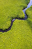
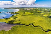
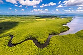
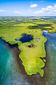
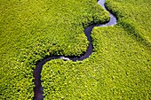
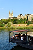
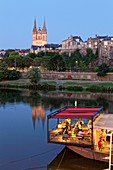
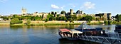
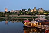
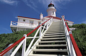
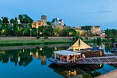
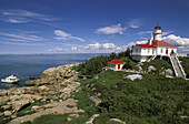
13929872 - France, Caribbean, Lesser Antilles, Guadeloupe, Grand Cul-de-Sac Marin, heart of the Guadeloupe National Park, Grande-Terre, Morne-à-l'Eau, Canal Cove, aerial view on the widest mangrove belt of the Lesser Antilles, Biosphere Reserve of Guadeloupe, here the Canal des Rotours, dug over nearly 6 km at the beginning of the 19th century (1826-1830) by hand of Men, slaves, to allow the drainage of the plain\n13933770 - France, Caribbean, Lesser Antilles, Guadeloupe, Grand Cul-de-Sac Marin, heart of the Guadeloupe National Park, Grande-Terre, Morne-à-l'Eau, Canal Cove, aerial view on the widest mangrove belt of the Lesser Antilles, Biosphere Reserve of Guadeloupe, here the Canal des Rotours, dug over nearly 6 km at the beginning of the 19th century (1826-1830) by hand of Men, slaves, to allow the drainage of the plain\n13931919 - France, Caribbean, Lesser Antilles, Guadeloupe, Grand Cul-de-Sac marin, heart of Guadeloupe national park, Grande-Terre, Morne-à-l'Eau, Canal cove, aerial view on the wider mangrove belt of the Lesser Antilles, Guadeloupe Biosphere Reserve, here the Canal des Rotours, dug for nearly 6 km at the beginning of the 19th century (1826-1830) by hand of men, slaves, to allow drainage of the plain\n13935986 - France, Caribbean, Lesser Antilles, Guadeloupe, Grand Cul-de-Sac Marin, heart of the Guadeloupe National Park, Grande-Terre, Morne-à-l'Eau, Canal Cove, aerial view on the widest mangrove belt of the Lesser Antilles, Guadeloupe Biosphere Reserve\n13934368 - France, Caribbean, Lesser Antilles, Guadeloupe, Grand Cul-de-Sac Marin, heart of the Guadeloupe National Park, Grande-Terre, Morne-à-l'Eau, Canal Cove, aerial view on the widest mangrove belt of the Lesser Antilles, Biosphere Reserve of Guadeloupe, here the Canal des Rotours, dug over nearly 6 km at the beginning of the 19th century (1826-1830) by hand of Men, slaves, to allow the drainage of the plain\n71366446 - France, Maine et Loire, Angers, the river port, restaurant pizzeria L'eau à la Bouche with Saint Maurice cathedral71366449 - France, Maine et Loire, Angers, the river port, restaurant pizzeria L'eau à la Bouche with Saint Maurice cathedral71366453 - France, Maine et Loire, Angers, the river port, restaurant pizzeria L'eau à la Bouche with Saint Maurice cathedral and the castle of the Dukes of Anjou71366448 - France, Maine et Loire, Angers, the river port, restaurant pizzeria L'eau à la Bouche with Saint Maurice cathedral and the castle of the Dukes of Anjou70327169 - Lighthouse, Pot à l'Eau-de-vie island, Quebec, Canada71314687 - France, Maine et Loire, Angers, restaurant pizzeria L'eau à la Bouche and the castle of the Dukes of Anjou in background70327168 - Lighthouse, Pot à l'Eau-de-vie island, Quebec, Canada